BVLOS and night drone flights: what stood in the way was never regulation
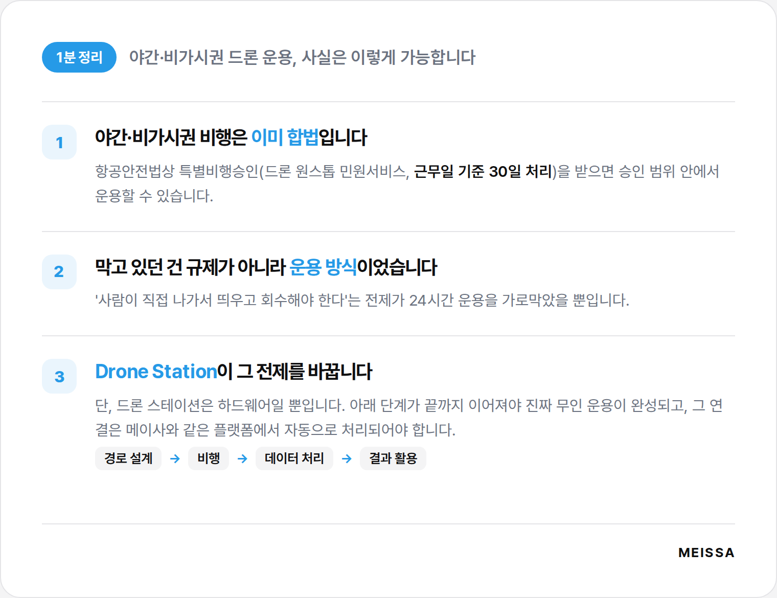
One-minute recap! Night and BVLOS drone operations are, in fact, possible today.
Night and BVLOS flights are already legal. Under the Aviation Safety Act, once you obtain Special Flight Approval (via the Drone One-Stop service, processed within 30 business days), you can operate within the approved scope.
What held things back was the operating model, not regulation. It was simply the assumption that 'a person has to go out, launch, and retrieve the drone' that blocked 24/7 operation.
The Drone Station changes that assumption. But a drone station is only hardware. True unmanned operation is complete only when route design → flight → data processing → putting results to use are all connected, and that chain has to be handled automatically on a platform like Meissa.
BVLOS and night flight are already open via 'Special Flight Approval'
Ordinary drone flight is permitted only between sunrise and sunset, and only within the range where the pilot can see the aircraft with the naked eye. Flying at night (after sunset to before sunrise) or beyond visual line of sight (BVLOS, a range where the aircraft is hard to see with the naked eye) goes past these rules, but that does not make it impossible. Under Article 129(5) of the Aviation Safety Act, once you obtain Special Flight Approval, night and BVLOS flight is possible within the approved scope. This is not some newly created scheme but an already well-established procedure.
Applications are accepted in one place, the 'Drone One-Stop service (drone.onestop.go.kr)'. Once the regional aviation administration receives the application, the Korea Institute of Aviation Safety Technology carries out a safety-standard inspection that includes an on-site check, and the regional aviation administration issues the final approval and certificate. The processing period is 30 business days (90 days in special circumstances); night flight is typically valid for a set period, and safety requirements such as LED position lights are attached.
The point is clear. BVLOS and night operation is not an 'area you cannot get permission for' but an 'area you can enter by following the procedure.'
When the operating premise changes, the value of the Drone Station changes
Once operating hours extend into nights, early mornings, and weekends, the very nature of the data a site accumulates changes completely. Drone imaging so far has been tied to 'a day when the pilot goes out, during daytime hours when the weather cooperates,' closer to a snapshot taken once or twice a month. Work advances every day, yet the eyes watching that change were inevitably intermittent. As operating hours widen, the site is recorded even after workers have gone home, the imaging cycle tightens to a daily or weekly cadence, and the staffing burden disappears
.
At the center of this change is the drone station. A drone station is infrastructure that handles, unmanned, the whole process of the drone taking off on a set schedule, carrying out its mission, returning, and recharging. The wider the available operating window, the steeper the drone station's utility curve becomes, because the number of flights with the same equipment rises while the labor cost that used to go into each one converges toward zero. The value becomes especially clear for civil-engineering sites that must survey large areas periodically, urban building sites where imaging hours are constrained by complaints and safety, and public-sector sites that require regular reporting.
But does bringing in a drone station alone finish the automation?
Here we need to address the most common misconception. Does installing a drone station complete unmanned automation? What a drone station does is limited to launching, charging, and retrieving the aircraft. It is excellent hardware in its own right, but hardware alone does not fully automate on-site work. For unmanned operation to truly run, three things must mesh: (1) route design matched to the approved scope, (2) automated data processing, and (3) putting the results to use. If only the imaging is unmanned while processing is manual, it stays 'half automation.'
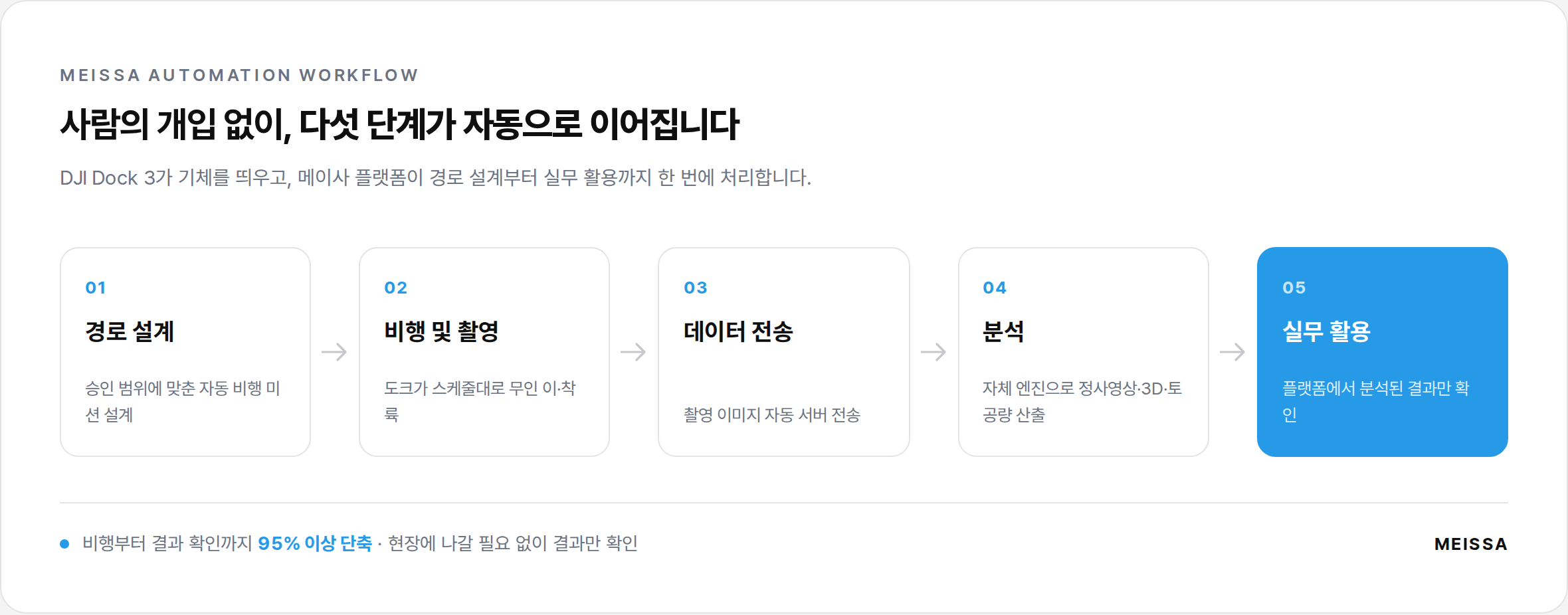
Closing this cycle is the role of a drone platform like Meissa. With its own 3D mapping engine and autonomous-flight integration, Meissa automatically handles the entire workflow of 'route design → flight and imaging → data transfer → analysis → practical use' on a single platform.
You design an automated flight mission matched to the approved scope, and the captured data is processed entirely on Meissa's servers by its own engine, from the pre-flight route to GCP (Ground Control Point) setup and on-site photo analysis. Since you only need to check the analyzed results on the platform without going to the site, the time from drone flight to reviewing results is cut by more than 95%. It is also worth noting that Dock 3 integration requires no separate charge, and captured images are automatically transferred to Meissa's servers, securing your data as well. (You can see how it works in detail in how Dock 3 and Meissa transform the job site.)
A drone station is general-purpose hardware anyone can buy. The difference is decided in what comes next: how accurately the captured data is processed by a proprietary engine, and how seamlessly everything from processing to delivery is connected. In fact, Shinsegae E&C has adopted the Meissa platform across all of its sites nationwide, and is pursuing operational automation built on autonomous drone stations alongside it.
The question shifts from 'is it possible' to 'how should we design it'
What blocked BVLOS and night flight was never regulation. The path was already open through Special Flight Approval; what stood in the way was the operating model that 'a person has to launch it in person.' Now that the drone station has broken down that premise, the question has moved from 'is it possible' to 'how should we design it to fit our site.' We recommend starting with a fit assessment together, looking at whether your site suits always-on unmanned operation and where to begin.
* The regulatory and procedural information in this article is based on Article 129 of the Aviation Safety Act and Article 312-2 of its Enforcement Rules, and on guidance from the Drone One-Stop service and the Korea Institute of Aviation Safety Technology. Actual requirements and processing times may vary with site conditions and the judgment of the competent regional aviation administration, so specific flight plans should be confirmed in advance through the Drone One-Stop service.
⚡ 30-Second Check
Which Meissa service fits your site?
Answer a few questions and we'll recommend the service that fits your site right away.
Question 1 / 425%
Step 1
Are you currently using the Meissa platform?
Our recommendation depends on whether you already use it.
Step 2
Which side handles your work?
The right service differs for on-site staff and head-office staff.
Step 3
Do you have staff at the site who can operate drones?
The support you need depends on whether you can do drone imaging.
Step 4
Do you need imaging support?
We'll find the support model that fits your site.
Step 4
What is the most burdensome task at your site?
Please choose the concern that applies.
Step 5
Within progress-billing / earthwork tasks, which part is especially tough?
We'll recommend the service that fits your concern exactly.
Step 3
What is the head office's biggest concern?
Please choose the situation that applies.
Step 4
Which stage are you at right now?
The most effective service depends on your stage.
Step 4
How are you currently handling safety management?
The impact of adoption depends on your current approach.
🚁
Recommended service
Regular Imaging Service
You can secure site data on a regular basis even without drone operators. Meissa's specialists visit the site in person to capture imagery and even calculate earthwork volume for you.
Included services
🚁 Regular Imaging Service🛰️ Drone Station + Meissa Platform
🛰️
One step further — always-on unmanned operation
Drone Station + Meissa Platform
Instead of a regular service where someone goes to the site every time, placing a drone station means the site is recorded automatically 24/7 with no one present. Night and BVLOS flights can also be operated legally once you obtain Special Flight Approval, so you can tighten the imaging cycle from once or twice a month to a daily or weekly cadence.
A drone station is infrastructure that takes off, images, returns, and recharges on its own to a set schedule. But hardware alone is only half automation. route design → flight/imaging → data transfer → analysis → practical use — the Meissa platform must handle all of it at once with its own 3D engine for true unmanned operation to be complete. Dock 3 integration has no separate charge, and imaging data is automatically sent to Meissa's servers, securing it as well.
When you need an urgent or one-off assessment of site conditions, Meissa's staff quickly visit the site to handle imaging and data collection for you. They can respond fast even in bad weather or unexpected situations.
If you have no drone operators or still find it hard to use, Meissa can help you directly. We can capture imagery for you as a service, or you can build your own capability through the training program. Training runs quarterly, and we'll notify you when the next session opens.
✅ Registered! We'll let you know when the next session opens.
🚁
Recommended service
Custom Imaging Service
No drone operators? No problem. Meissa's specialists visit the site in person to carry out drone imaging and data collection for you. Both regular contracts and urgent one-time services are available.
We handle the entire earthwork surveying process for you, from drone imaging to precise DTM generation, quantity takeoff, and earthwork tables. You can end standard disputes with subcontractors using objective data.
Break free from the manual cross-section drawing work that repeats every month. We deliver CAD files based on the latest drone data, in your own design format. Provided quickly and at a reasonable cost whenever you request.
From worker and vehicle location tracking to danger-zone alerts and AI video monitoring — every safety-management record is logged automatically on the platform, becoming objective evidence you can pull up instantly when needed.
From bid review to pre-groundbreaking site assessment, the head office can flexibly allocate 10 platform analysis credits without per-site contracts. We'll suggest up to 3 use points per site.
Precise earthwork volume data is key to managing budget risk on active sites. We compare actual construction progress after groundbreaking against the design baseline to provide accurate quantity data.
It looks like you're already using the Meissa platform effectively. Keep making active use of site data to carry on ever smarter site management. If you're curious about new features or services, reach out to your contact anytime.
Even if nothing is urgent right now, adopting the Meissa platform lets you easily put drone-based site data to work. The standard for site management changes.