
When preparing for a drone survey these days, you often hear something like this: "With an RTK drone, you no longer need GCPs." It is a tempting claim. Anyone who knows the field understands how cumbersome it is to install, survey, and maintain Ground Control Points (GCPs) one by one across a large, rugged site. But can RTK really replace GCPs entirely?

Before getting into the main discussion, let's first organize the three key concepts used in position correction. The "position correction" methods that match the coordinates of drone-captured imagery to the actual terrain fall broadly into the following.
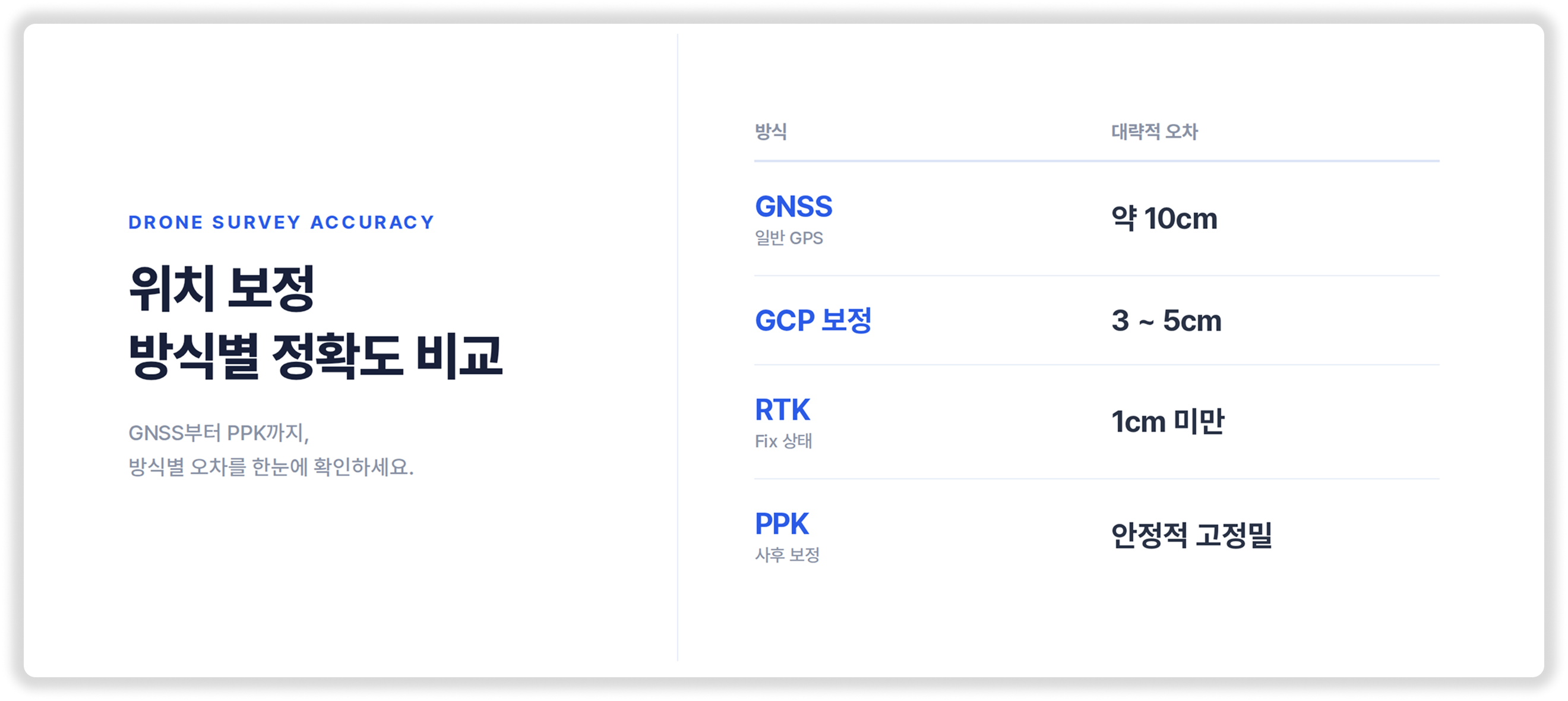
A rough comparison of accuracy looks like the above. Judging by the numbers alone, RTK appears to be the most accurate. And indeed it is, under ideal conditions with a perfect signal—that is, when RTK maintains a "Fix" state. What deserves attention here, however, is that premise of "ideal conditions."
Let's first note why RTK is drawing so much attention. Whether you look at time, cost, or safety, the benefits RTK provides are undeniable. The issue emerges when you take one step further from here.
RTK's high accuracy presupposes perfect "signal conditions." But field signal conditions can never be the same every time. As a result, operating RTK on its own creates the following blind spots.
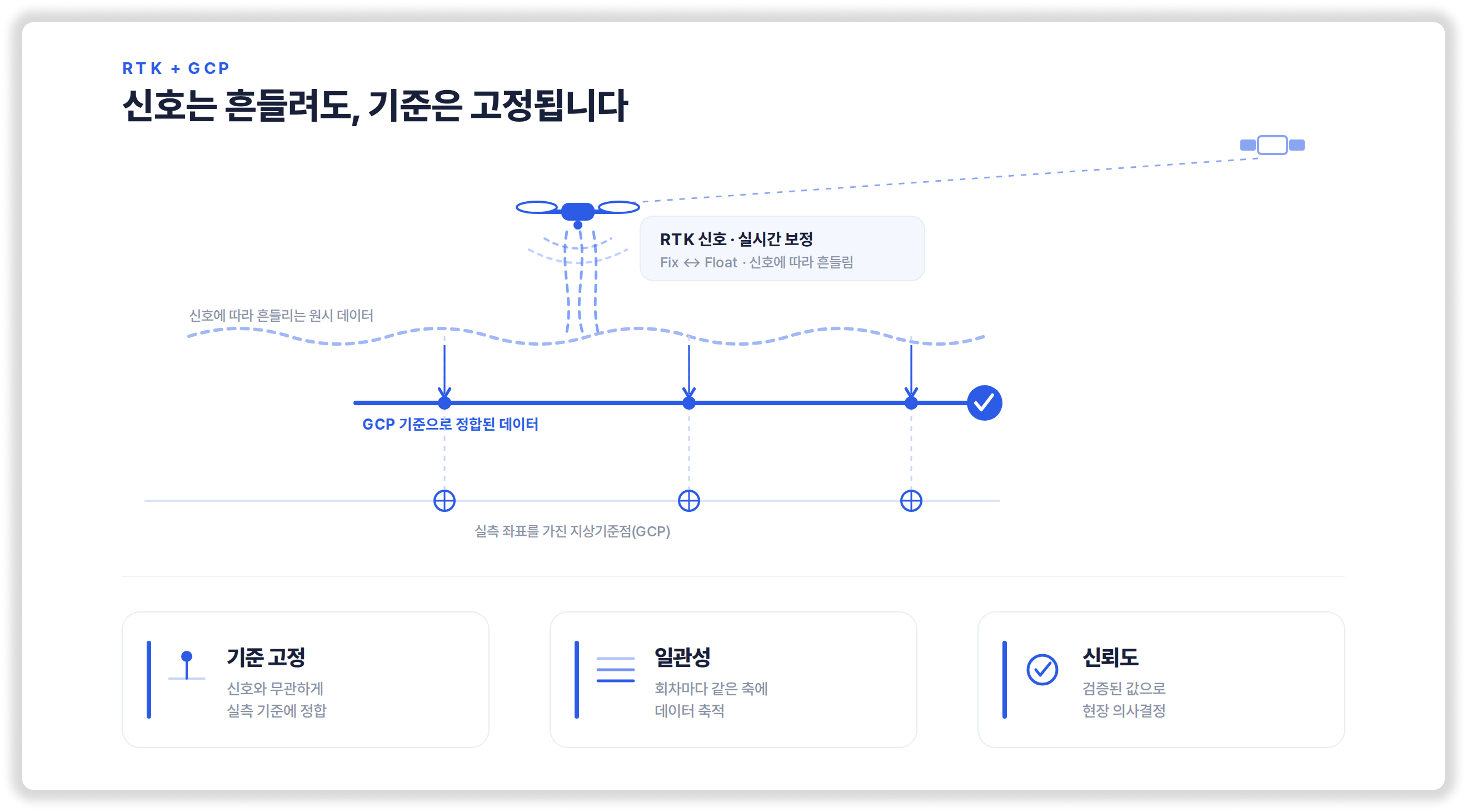
Meissa, too, actively uses RTK technology in the field and fully supports the related data processing. But as a party responsible for field data, rather than simply choosing between "RTK or GCP," we recommend a combination that gains efficiency with RTK and verifies those results with a small number of GCPs. The benefits of adopting both correction methods together are as follows.
What matters here is that this does not mean installing GCPs densely across the entire site as in the past. Combining efficiency-driven RTK operation with a minimal number of verification control points is closer to the practical answer that captures both accuracy and reliability at once.
Accuracy is a concept that includes "verification." It is hard to prove with a single number. Strictly speaking, unverified accuracy is not accuracy but something closer to expectation. The reason Meissa recommends using RTK and GCP together is simple: to propose only data that can truly be trusted in the field—data on which the person in charge can base their decisions. What works in words and what works on site are different things.
If you are curious about the capture and correction method best suited to your current site conditions, please feel free to reach out anytime.
Q. How is the PPK method mentioned in the introduction used in the field? How does it differ from RTK?
A. Because PPK (post-processing) does not rely on a real-time communication network, it becomes an excellent alternative to RTK on mountainous terrain or coastal sites with severe radio shadow. Even if real-time communication is lost, the data can be corrected after capture to improve precision. That said, PPK is likewise only a technique for precisely capturing the drone's flight trajectory—it is not an independent reference that "verifies" whether the output matches the actual ground surface. Therefore, while you choose whichever method—RTK or PPK—is advantageous depending on the site's communication conditions, the basic principle of combining a small number of GCPs to verify the final data applies the same way.
Q. If I set up my own base station on site to stabilize the signal, wouldn't perfect surveying be possible even without GCPs?
A. Installing your own base station greatly improves communication latency and dropout issues compared with network RTK. However, it is difficult to completely block "multipath error"—the phenomenon where radio waves reflect off cut slopes or high-rise steel-frame structures. Even if the device shows a "Fix" reception state, there remains a possibility of a slight deviation from the actual terrain coordinates, so a minimal number of verification GCPs is still needed to prove the integrity of the data.
Q. What exactly does the "small number of GCPs" that Meissa recommends mean in terms of placement?
A. It does not mean you must densely cover the entire site in a 200–300 m grid pattern as in the past. Since RTK (or PPK) does an excellent job of establishing the overall skeleton of the terrain data, it is enough to place just 3–4 perimeter points surrounding the site boundary and 1–2 checkpoints at the center where terrain changes are large or at key process zones. It is an efficient setup that obtains reliable data while reducing the labor of installing control points by more than 80% compared with before.
Q. I plan to fly a drone periodically to calculate earthwork volume for progress-payment inspection. Do I have to install and survey GCPs anew each time?
A. No. You only need to install a small number of GCPs once, properly, as permanent points (or markers that can be preserved long-term) on solid ground at the site perimeter or on structures that will not be damaged during construction. If you align the data to these fixed GCPs at every round of capture, the time-series data always accumulates on the same axis even when the weather or communication conditions differ. This lets you minimize errors and secure a highly consistent and accurate basis for earthwork volume calculations to submit to the client or the supervisory team. If an installed GCP is lost or needs reinstallation and resetup, please contact Meissa and we will help with the setup.

