
In recent years, the construction industry has continually faced safety concerns caused by hard-to-predict ground subsidence accidents. The need for technical solutions that can detect and respond in advance to minute ground changes invisible to the naked eye is greater than ever.
Meissa, too, has continuously invested in developing a range of satellite imagery analysis technologies, including ground-monitoring solutions that leverage InSAR technology. Today, focusing on ground subsidence as a core challenge on construction sites, we will look at how satellite data technology is presenting a new paradigm for construction safety.

%202.png)
Ground subsidence accidents have continued across the country in recent years. In Korea, 867 ground subsidence incidents occurred over the past five years, with more than 45 reported in the Seoul and Gyeonggi region alone this year. Of these, 31.8% occurred in Seoul and 21.2% in Gyeonggi, meaning safety threats persist in urban centers and large-scale construction zones. Because ground subsidence progresses gradually without visible cracks or depressions, its changes are difficult to detect until an accident occurs. Once it happens, recovery takes considerable time and cost, and in some cases it can lead to loss of life.
For this reason, site managers are looking for ways to monitor ground conditions 'in advance, more broadly, and more precisely.' Traditional methods such as boring and ground-measurement instruments offer high precision, but their installation coverage is limited and the cost of long-term observation is considerable. Drone surveying also has significant advantages in terms of speed and resolution, but it has limits for flight-restricted areas and long-term monitoring of extensive zones. It is precisely at this point that the value of satellite-based data technology is drawing attention.
.png)
There are several types of data collected from satellites. Electro-optical imagery captures sunlight reflected from the ground surface and provides color images similar to what we see with our eyes, but because it lacks the phase information needed to measure minute vertical displacement of the ground, it has limits for detecting subsidence. Elevation data provides three-dimensional height information of the terrain, but its measurement precision is only on the order of several meters, making it hard to capture millimeter-scale ground changes. What overcomes these constraints is synthetic aperture radar, or SAR (Synthetic Aperture Radar). SAR emits microwave pulses toward the ground surface and receives the reflected signals, enabling all-weather, 24-hour image acquisition regardless of weather conditions. High-resolution images can be obtained by exploiting the effect in which the antenna's effective diameter grows by the distance the satellite or aircraft travels while continuously receiving microwave pulses.
The key here is InSAR (Interferometric SAR) technology. InSAR is an analysis technique applied to images acquired by SAR satellites, comparing SAR images captured at different times to analyze phase differences. This makes it possible to calculate changes in surface elevation down to the millimeter. For this reason, data obtained with InSAR is especially useful for observing ground subsidence. A single observation can cover an extensive area spanning dozens of square kilometers, so it can be used for site-stability review before construction, for monitoring subsidence in nearby areas during construction, and for facility-safety monitoring after completion. It can track subsidence trends over long periods and efficiently manage the ground stability of large-scale infrastructure such as roads, railways, and urban centers, while also enabling early identification of when displacement exceeds a threshold, allowing proactive response to accidents.
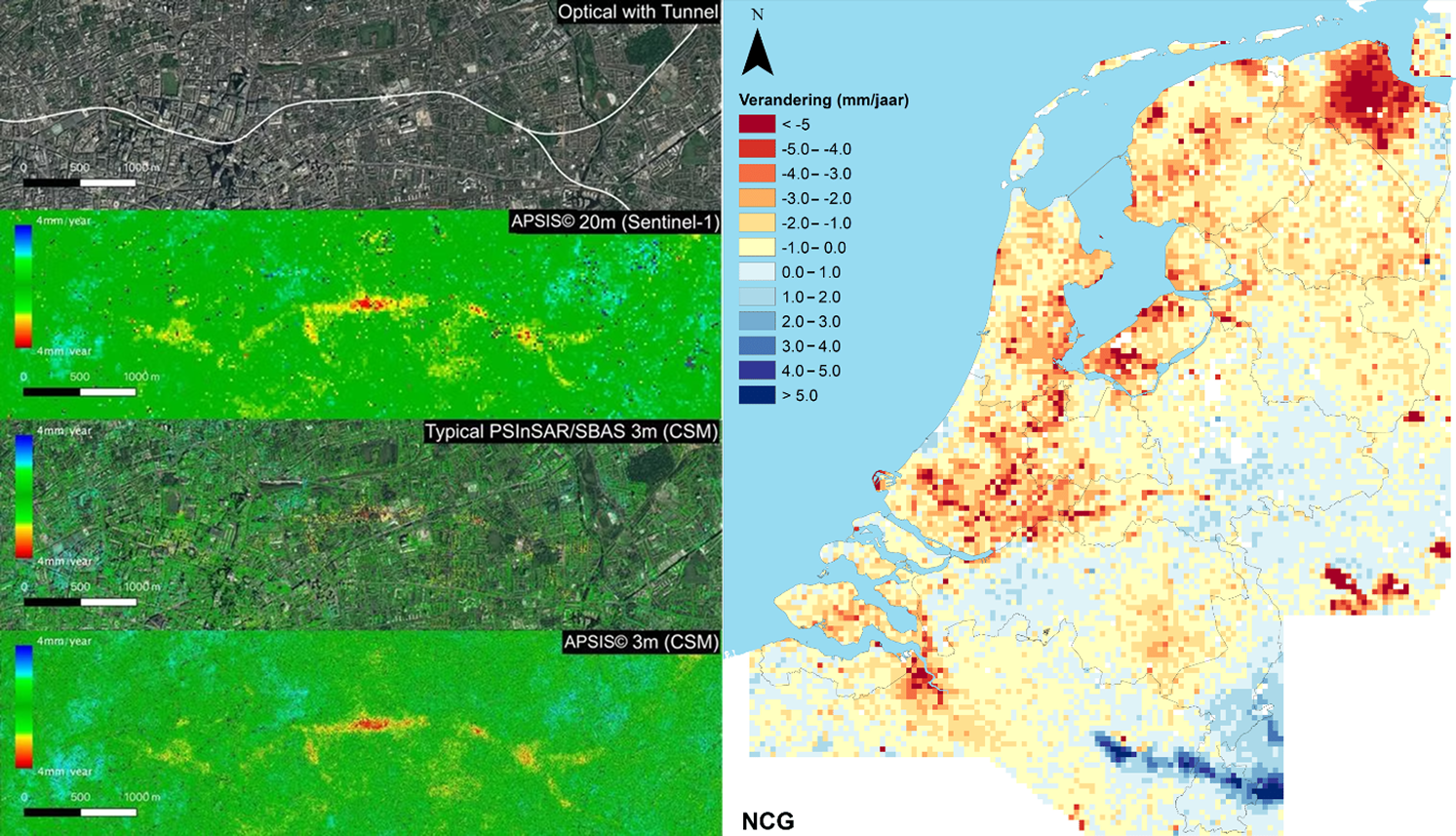
Satellite data is in fact used to monitor ground conditions worldwide. In London, the Crossrail project used InSAR-based time-series analysis to detect and monitor nonlinear ground movements arising during subway tunnel excavation, serving as a key means of complementing traditional leveling measurements. In the Netherlands, a nationwide ground subsidence map integrating PS-InSAR, GNSS, and gravity data is operated at the national level. In Mexico City as well, since 2002 Sentinel-1-based PS-InSAR has quantitatively measured severe ground subsidence of up to 500 mm/year, identifying subsidence risks around the subway and critical infrastructure in advance.
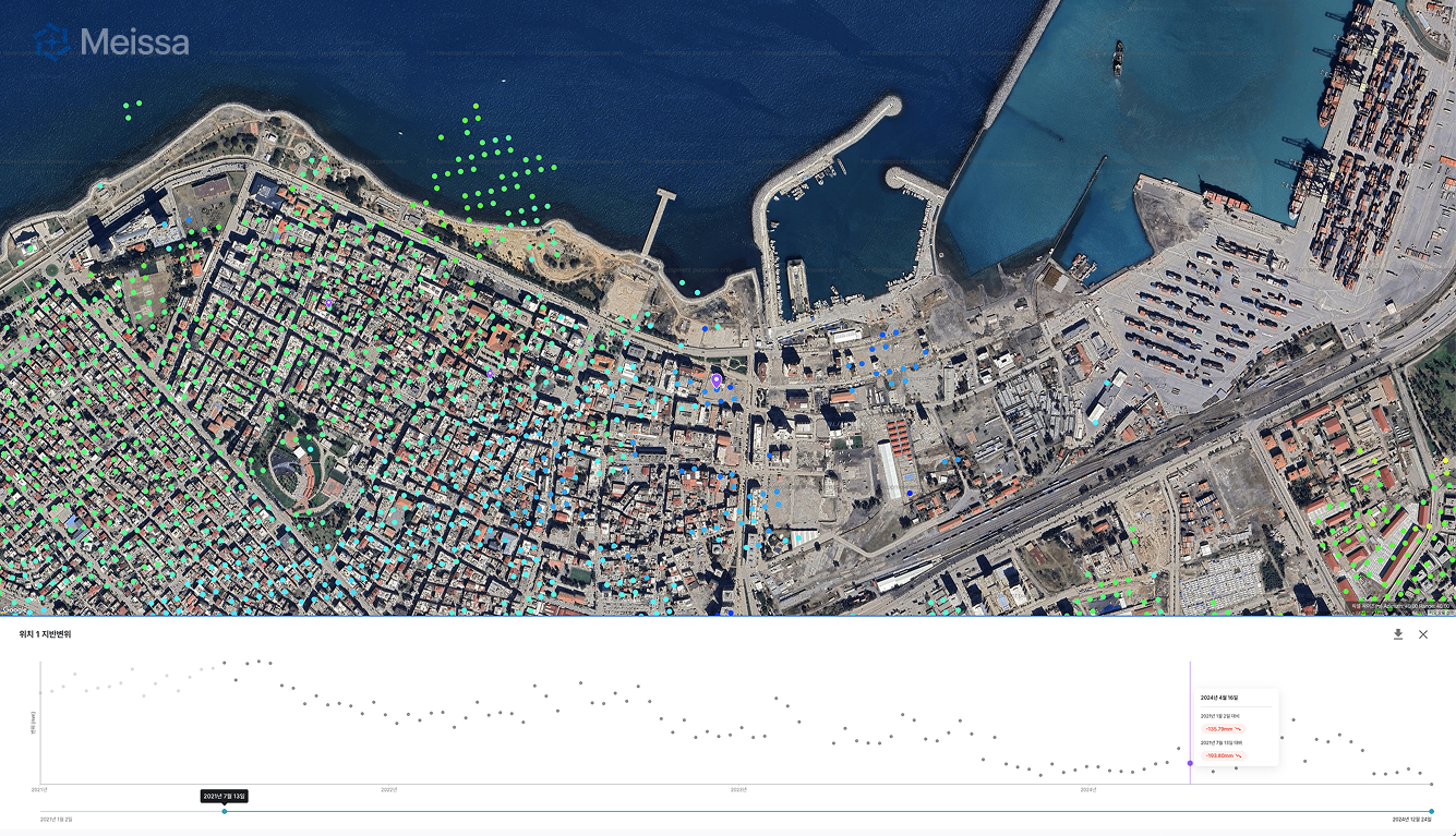
As a spatial-information solutions company that leverages drone and satellite data, Meissa actively works with this kind of satellite data. Through drone and satellite observation, we capture, analyze, and provide a range of spatial information needed on construction sites, including ground subsidence tracking. Recently, we provided satellite-data-based process-management solutions to the construction sites of Japan's Takenaka Corporation and Dongbu Construction, supporting the safety and efficiency of their sites. By converting complex satellite data into easy-to-understand visualizations and providing customized analysis results tailored to on-site conditions, we help practitioners make decisions.
Ground subsidence progresses slowly in places invisible to the eye. It is more important than anything to move away from responding after the fact and instead detect and prepare for risks before they occur. Going forward, Meissa plans to advance its satellite-data solutions in line with the rising demand for safety and efficiency across industries, and to contribute to strengthening the prediction and management capabilities of construction sites.

